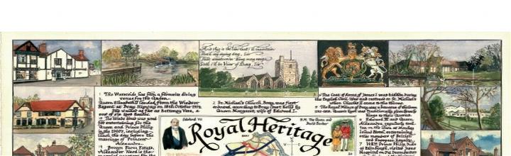
 In celebration of the Queen's Diamond Jubilee year in 2012, "Royal Heritage in the Parish of Bray" maps the connections between the Parish of Bray and British Royalty over the years in detailed pictorial form. The map includes a description of each of the 19 scenes depicted and a separate location index.This map continues the theme established by the "Parish of Bray in Berkshire" map, commissioned by Bray Parish Council and compiled & drawn by John Woodcock in 1999 for the Millennium. The research work for the map was supported by Margaret Pierce and Geoff Hayes. The original of "Royal Heritage in the Parish of Bray" was commissioned by Julie Graham and created in ink and watercolours by Liz Cooper. Copies of the map, produced by Ruscombe Printing, are being sold in aid of Bray Parish Charities in two sizes, unmounted and unframed. Small maps (462mm x 348mm, 16 11/16ins x 13 11/16ins) are £15 each and Large maps (769mm x 578mm, 30 1/4inx x 22 3/4ins) are £25 each You can order your copy at royalheritageinbray.co.uk
0 Comments
Leave a Reply. |


The
|
 RSS Feed
MONKEY ISLAND LANE ~ BRAY-ON-THAMES UK

Being of interest to local residents, visitors and all curious types
MonkeyIslandLane.org is a wholly independent organisation. The views and opinions expressed on this web site and related social media are soley those of the original author.
These views and opinions do not necessarily represent those of the Residents or Businesses of Monkey Island Lane or Bray-on-Thames.
#MonkeyIslandLane #MonkeyIsland #Bray #BrayStudios #Thames #Windsor #Maidenhead #RBWM
These views and opinions do not necessarily represent those of the Residents or Businesses of Monkey Island Lane or Bray-on-Thames.
#MonkeyIslandLane #MonkeyIsland #Bray #BrayStudios #Thames #Windsor #Maidenhead #RBWM
© MonkeyIslandLane.org